Shetland Geopark
LEADER funded two Shetland Geopark projects under the 2007-2013 programme, the production of a leaflet 'The Shetland Ophiolite Trail' and a partnership project for Geopark Interpretation using new technologies.
Geology Trails Unst & Fetlar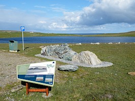
This project aimed to help visitors understand the variety of rock formations in Unst and Fetlar, in particular the shared formation of ophiolites, a rare formation of former ocean crust, and contrast the geological differences between the two isles. A trails leaflet “The Shetland Ophiolite Trail” was produced to accompany on-site information panels and geological exhibits with funding from LEADER Convergence and Scottish Natural Heritage.
Geopark Interpretation using new technologies and partnership project HINT (Heritage Interpretation using New Technologies)
The aim of this project was to use new technologies to augment traditional interpretation by employing a range of media – audio, visual and textual – to link Shetland’s natural, cultural and geographical heritage sites and make information available in a portable format for users to access at their own pace. The project developed a map based application for smart phones introducing users to Geopark Shetland. This formed part of a wider transnational LEADER funded project led by Shetland Geopark with partners from other Geoparks in North Pennines England, Hondsrug Netherlands and Chablais France. Each of the partners developed their own heritage interpretation using various new technologies and they combined their experiences to produce “Exploring new technologies for heritage interpretation: A guide to developing digital projects” available for download at http://www.hintproject.eu
Geopark Shetland website here
All Case Studies